|
UPPER
NIAGARA RIVER FISHING TECHNIQUES AND HOT SPOTS
PLEASE
NOTE: Author unknown. If anyone has an idea of who the author is, we
would like to know so we can credit this writer for such a great
article. Some historic, famous names are resurrected at the beginning of
this article. These were men that knew the upper river like the backs of
their hands. This article and map were put on it’s own page on this
website because of its map and its importance. Everything it says, still
holds true today. Nothing changed.
“In the Niagara River,
successful angling is dependent upon an understanding and application of
a technique developed for fast water fishing over many years. Some of
the historical guides that have developed this technique are Hans
Mang, Hamp Howard, Freddie Mauser, Patty Hoctor and Bill Dekdebrun.
In the upper Niagara River
you’ll find, first of all, the famous fighting Niagara River small-mouth
bass, yellow pike, northern pike, and muskellunge. In addition, anglers
fishing from like banks and docks have been successful in landing rock
bass, perch, calico bass and bullheads. There are a number of large
sturgeons taken from the waters of the Niagara every year.
Related: Is a Fishing Pole Holder With Bite Alarm Worth It?
Many people have made the
statement that they have fished in the river any number of times and
have yet to catch their first bass. That’s because the wily
bronze-back confines his activities to certain weed beds, wrecks, rock
ledges, and deep holes that in many cases cover less area than a normal
living room. The successful bass fisherman has managed to range these
small-mouth lairs, and any fishermen with a reasonable amount of ability
can manage to become a Niagara River bass fishermen by using our marked
map and establishing his own ranges.
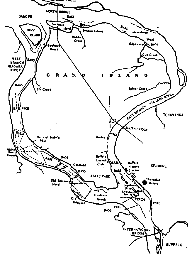
Our map is self-explanatory.
Solid lines denote bass drifts, and broken lines designate areas where
you may troll for muskellunge.
Other than to say it is
possible that you may pick up a good number of yellow pike while fishing
for bass on these designated drifts, we’ll not indicate any specific
yellow pike grounds except those at the head of the river and Thompson’s
Hole. It would be physically impossible to give accurate land ranges for
any of these spots. Average water depth of bass fishing drifts will
range from six feet to ten feet except for certain deep holes, which are
indicated on the map.
In regard to rigging for
bass, most successful anglers use ten to eighteen pound test braided
Nylon line with a snap and swivel at the end. Recently more anglers are
using spinning tackle and the light monofilament lines, also with a snap
and swivel. Fastened to the snap is a sinker very similar in shape to
the large chugging wires used in the lake and river trolling. However,
these are miniature replicas . . . the wire being only seven to nine
inches in length and the sinker set close to the top weighing only 1/2
to 3/8 of an ounce. Snapped into the same snap and swivel is a
three-foot gut leader with a No. 21 or No. 22 Cincinnati bass hook
without eye.
The universal bait is the
soft-shelled crab properly set up. By “setting up” we mean that
the crabs must be reasonably soft and of the consistency of sponge
rubber. Our experience has been that the smaller crab is most
successful. Late in August and early September, many fishermen switch
from crabs to chub and moddock, but nine out of ten bass caught in the
river fall victim to the soft-shelled crab.
We locate our drift and get
above it because of the river current, drop the line over, allowing it
to get away from the boat about fifteen to twenty feet and drift over
our designated area. A bass generally will pick up the bait and make a
slight run. On feeling a bite, smart fishermen will immediately peel off
about ten feet of line allowing the bait complete freedom. This relieves
any strain on the line indicating that it is not natural. Then the hook
may be set and if you connect, you have a real fight on your hands.
You’ll notice from our map
that there is very good fishing on both American and Canadian sides of
the West River. Some especially good spots are from the head of Grand
Island to Oakfield Road on the Grand Island side, and from just below
Black Creek to Twin Poplars on the Canadian side. Another hot bed is
just above Staley’s Reef on the Grand Island side of the river near the
new parking area on the Niagara Frontier West River Parkway. This is
called the Clay Banks. Out from Staley’s Reef is a big hole called the
drop off and directly below the Reef is a fine bass area called the
Weed-Bed.
This should be fished about 3
or 4 feet outside the weeds. Both sides of the head of Navy Island have
produced fine bass fishing. There’ll a big weed bed there that is very
productive of bass. Surprisingly enough to many, you’ll see there’s a
long bass drift to the west side and above the head of Strawberry
Island. All of these spots marked on the map produce good catches of
black bass.
It is very important that you
try these spots at various distances from shore, because once you strike
a fish and take range, you will be able to get additional fish, as we
have mentioned before. The east branch of the Niagara River generally
has only a few places where there’s good bass fishing, although the East
River from Edgewater to the foot of the island has produced some of the
very finest bass. We hope these instructions and maps will help you in a
greater enjoyment of what we think is the finest fishing in the world.
|